University of Central Florida: Foreign invaders such as pythons and lionfish are not the only threats to Florida’s natural habitat. The native Carolina Willow is also starting to strangle portions of the St. Johns River.
Biologists at the University of Central Florida recently completed a study that shows this slender tree once used by Native Americans for medicinal purposes, may be thriving because of water-management projects initiated in the 1950s. Canals were built to control runoff and provide water for agriculture. The unintended consequence — stable water levels — allowed Carolina Willow to spread and thrive.
They now cover thousands of acres. Willows form impenetrable thickets that prevent boating and eliminate duck habitat. Willow thickets also use tremendous amounts of water, leaving less available for wildlife and people. The findings were published today in Restoration Ecology, the peer-reviewed journal of the Society for Ecological Restoration. The St. Johns Water Management District funded the study.
While the trees previously were kept in check by natural annual flooding, they can now be found thriving in wetlands, swamps and marshes. Some trees grow as tall as 35 feet. The leaves of the tree contain salicin, which is the compound behind the pain-relieving effect of salicylic acid found in aspirin.
UCF professors Pedro F. Quintana-Ascencio and John Fauth worked with Kimberli Ponzio and Dianne Hall, scientists from the St. Johns River Water Management District, to run experiments that found ways to control the willow, which is taking over marshes in the upper St. Johns River basin....
St. John's River near Orange City, Florida, shot by Mwanner, Wikimedia Commons, under the Creative Commons Attribution-Share Alike 3.0 Unported license
Showing posts with label Florida. Show all posts
Wednesday, 9 January 2013
Thursday, 27 December 2012
Planners wary of coastal sea rise in St. Augustine area
Peter Guinta in the Florida Times-Union: Scientists studying the effect of higher sea levels on the 100,000-acre Matanzas Basin — which runs from Anastasia Island to Crescent Beach — say that rising waters will turn coastal marshes into open water and coastal forests into marshes. U.S. Army Corps of Engineers projections point to a potential 3- to 7-inch sea level rise along St. Johns County’s coast over several decades.
Kathryn Frank, assistant professor at the Department of Urban and Regional Planning at the University of Florida, said coastal marshes are an important wildlife habitat that should be preserved. “Higher sea levels come from global warming,” she said, explaining that rising average temperatures heat up and thus expand sea water. The higher temps also melt ice and glaciers on land masses such as Greenland and the Antarctic. That ice melt then runs into the sea.
“We’re land-use planners who focus on preserving ecosystems and habitats,” Frank said. Teams of scientists are working for UF and the Guana Tolomato Matanzas National Estuarine Research Reserve on this project, which began in November 2011 and runs to October 2014.
A workshop Dec. 6 at Flagler College, “Planning for Sea Level Rise in the Matanzas Basin,” was designed to inform the public that rapid sea level rise can mean flooding, coastal erosion, saltwater intrusion into the water supply, storm surges moving farther inland and habitat and species changes in the Matanzas Basin.
Michael Shirley of the Guana reserve said his agency has tracked sea levels for quite a while. “We have many salt marshes [along our coast], [which are] some of the most sensitive habitats to sea level rise,” he said. “Salt marshes are important to our coastal economy, affecting ecotourism, fishing, absorbing the impact of storms, helping to detoxify runoff. They act as a water filter by absorbing nutrients. They are the canary in the coal mine for sea level rise.”...
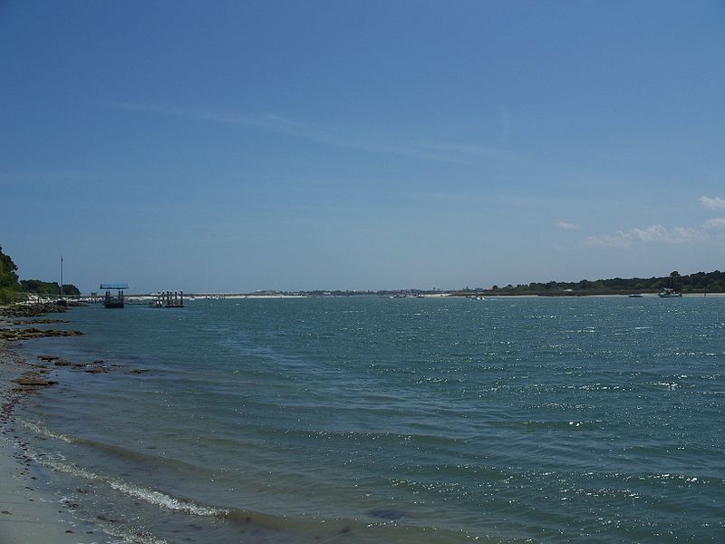
Matanzas River near Fort Matanzas, in St. Johns County, Florida, shot by Ebyabe, Wikimedia Commons, under the Creative Commons Attribution-Share Alike 3.0 Unported license
Kathryn Frank, assistant professor at the Department of Urban and Regional Planning at the University of Florida, said coastal marshes are an important wildlife habitat that should be preserved. “Higher sea levels come from global warming,” she said, explaining that rising average temperatures heat up and thus expand sea water. The higher temps also melt ice and glaciers on land masses such as Greenland and the Antarctic. That ice melt then runs into the sea.
“We’re land-use planners who focus on preserving ecosystems and habitats,” Frank said. Teams of scientists are working for UF and the Guana Tolomato Matanzas National Estuarine Research Reserve on this project, which began in November 2011 and runs to October 2014.
A workshop Dec. 6 at Flagler College, “Planning for Sea Level Rise in the Matanzas Basin,” was designed to inform the public that rapid sea level rise can mean flooding, coastal erosion, saltwater intrusion into the water supply, storm surges moving farther inland and habitat and species changes in the Matanzas Basin.
Michael Shirley of the Guana reserve said his agency has tracked sea levels for quite a while. “We have many salt marshes [along our coast], [which are] some of the most sensitive habitats to sea level rise,” he said. “Salt marshes are important to our coastal economy, affecting ecotourism, fishing, absorbing the impact of storms, helping to detoxify runoff. They act as a water filter by absorbing nutrients. They are the canary in the coal mine for sea level rise.”...
Matanzas River near Fort Matanzas, in St. Johns County, Florida, shot by Ebyabe, Wikimedia Commons, under the Creative Commons Attribution-Share Alike 3.0 Unported license
Subscribe to:
Posts (Atom)

